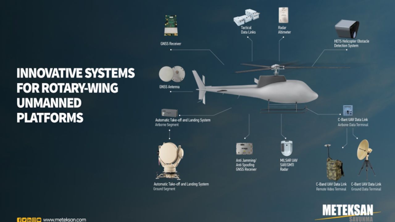
ISR Mission, Communication, Navigation and Flight Support Systems
Unmanned Systems that are servicing in the military, public security, government & law enforcement areas for many decades are pioneering in the new combat era with the evolving technologies in robotics and AI. UAVs are the key game changers widely used especially in homeland security for many decades where Rotary-wing Unmanned Aerial vehicles (RUAV) are primarily preferred by Navy and Land Forces for their VTOL and hover flight capability, long endurance or high capacity of mission payload. For successful mission, RUAVs are to be equipped with modern payloads and highly reliable mission subsystems that are developed with deep R&D work and excellent engineering competency.
Meteksan Defence has been developing high technology surveillance, communication and navigation system solutions for RUAVs operating in critical ISR missions, close-air support, fire-support, unmanned/ collaborative armed combat, transport in hazardous environments where manned operations are risky. These systems and end-products of Meteksan Defence that are tested and deployed in battlefield are state-of the art, military compliant, modular systems adjustable for optimal operational benefit.
MILSAR SAR/MTI Radar for UAS
Compact, Multi-Mode Airborne Surveillance Radar
MILSAR could be operated on Rotary-Wing unmanned air vehicles (RUAVs) with its easy installation feature. This high technology radar system has the same form-fit mechanical interfaces as standard 15” EO/IR sensor turret to be readily replaced with an EO/IR sensor. In addition, operating MILSAR together with an EO/IR sensor in a “slew-to-cue” fashion improves the effectiveness of the RUAV operations through maximizing wide area surveillance of RUAV and increasing attack capability. MILSAR in MTI mode detects and tracks potential moving targets which may be either low speed small size or fast moving one. In SAR mode, MILSAR facilitates the military personnel to detect, recognize and identify the fixed targets on the ground for surveillance purposes. SAR and MTI modes are fully operational even in adverse weather and low visibility conditions including cloud and fog.
Automatic Take-off and Landing System
Reliable Positioning Under GPS Denied and Adverse Weather Conditions
Due to the unprotected nature of GPS signals against various jamming attacks, OKIS provides a reliable solution, especially in wartime for the automatic takeoff and landing phases of RUAV’s. OKIS could also be used for improving takeoff and landing capability of RUAVs during adverse weather conditions and night operations. OKIS Airborne Segment having small size and weight could be used in almost any kind of RUAV’s without having any significant capacity degredation on payload capacity. OKIS Ground Segment provides a safe and precise take-off/landing by feding accurate RUAV’s 3D position information (range, bearing, elevation) to Ground Control Station (GCS).
HETS Helicopter Obstacle Detection System
High Performance with Lidar Technology
Helicopter platforms are widely used in adverse weather and low-altitude/high-manoeuvering conditions for mission success. At these circumstances, detection of the vertical and horizontal obstacles and alerting the auto pilot in a timely-manner is an important safety issue also for RUAVs. HETS is lidar equipment which uses 1550 nm wavelength fiber-laser, that detects obstacles such as wires, poles, trees etc. The system detects the obstacles and gives necessary alerts to the commanding pilots with aural and visual means.
UAV Data Link
High Resolution Video and Control Data Link
C-Band UAV Data Link is a LOS air-to-air and air-to-ground real time bi-directional communication system, that transmits Manned/Unmanned Systems command & control data and receives telemetry & high data rate real-time video data on ground system with highly reliable Electronic Warfare (EW) protection. C-Band UAV Data Link is designed to be competitive with similar systems in the market targeting the main goals as easily adaptation for various platforms and cost effectiveness in procurement and maintenance. In addition to these, operational use is supported by a remote video terminal subsystem which is suitable for back-carry and can be configured to allow communication at different distances.
Tactical Data Link
Common Operational Picture With Network Enabled Operational Support
KEMENT TDL is a TDMA-based, secured (crypto), jam-resistant, high-speed tactical data link system with relay capability for near-real time transmission of complex data sets. Kement TDL enables NEC (network-enabled capability) and NEW (Network Enabled Weapon) among Command Control (C2) Systems, land, sea and air platforms, ammunition (cruise missiles etc.), weapons and mission systems in the battlefield. It is used to share common operating picture and ISR data by relaying rover RUAV’s to mother ship and to other network central warfare modes.
Radar Altimeter
Miniature Design, Low Power Consumption
With its miniature design and low power consumption features, Radar Altimeter provides an efficient workload planning opportunity in any air platform. Radar Altimeters which can measure precisely up to 2500/5000 feet altitude, provide sensitive data even on platforms with high speed and high maneuverability and working in operations such take-off/landing, low flight, and ground-referenced navigation on different earth structures, including offshore operations.
GNSS Receiver
High Precision Location, Velocity and Time Information
Meteksan Defence GNSS offers high accurate and precised positioning GNSS technology to platforms. Meteksan Defence GNSS receiver solutions offer multi-constellation, multi-frequency tracking and features flexibility, low power consumption, field upgradeable software and and data logging. The products are designed for rugged dependability. Customers benefit from connectivity options for fast data transfer, as well as receiver configuration via Standard and user friendly interfaces. The GNSS receivers are designed for easy integration into multi-platforms.
GNSS Antenna
Custom and Reliable Antenna Solutions
Meteksan Defence GNSS antennas have been designed to support high accuracy air, land and marine applications. High-performance multi-band GNSS antennas are built with weather-resistant materials to allow operation in the harshest environments. In that respect, you can maximize your GNSS receiver's positioning performance with the optimal GPS or GNSS antenna for your application, which are manufactured in extensive range of single-band and multi-band GNSS (GPS, GLONASS, Galileo, BeiDou) antennas optionally in only L1 or L1/L2 frequency bands. With the high-tech antenna design infrastructure owned by Meteksan Defence, it also develops their own Controlled Reception Pattern Array (CRPA) antenna designs and offers a variety of antenna specific to the platforms. CRPA antennas are used for filtering jamming signals from the GNSS signals. Meteksan Defence can also provide multi-frequency and multi constellation with CRPA antenna solutions.
Anti-Jamming GNSS
Vital Solution in Combat Missions
Meteksan Defence develops and produces platform specific GNSS receiver systems with anti-jamming and anti-spoofing capabilities, which can output precise position, velocity and time information. In order to suppress jamming signals, spatial filtering methods are utilized. Phased array antennas are used for spatial filtering with respect to incoming signal direction, and jamming signals are separated from GNSS signals. Depending on the number of antennas used in spatial filtering, more than one jamming signal can be nullified. It is possible to obtain the direction of the GNSS signals by using phased array antennas. By using this information, while powerful jamming signals are nullified by the anti-jamming system, GNSS spoof signals can also be filtered.
Source: Meteksan Savunma